
As a UNICEF report reminded us this summer, the lack of water in some parts of the world is having serious consequences for people. This lack of access to water for populations is commonly referred to as “water stress”.
Today, several regions of the world are suffering from water stress. According to the World Resource Institute, 17 countries have an “extremely high” probability of water stress. These include India, Mexico, parts of China and, above all, most of the Near and Middle East.
This article aims to provide a better understanding of this problem and the issues involved. It also shows the role that technological and scientific progress can play. They will allow better understanding of causes and consequences of water stress in threatened regions.
What is water stress?
The lack of water for populations can result from political and social causes: waste of available resources, mismanagement, conflicts. This makes it impossible for entire populations to access water. But it is also linked to economic problems of resource distribution and the uses addressed.
Finally, water scarcity is also and above all the result of physical causes, indeed, in the desert there is generally a lack of water, whatever the management policy put in place.
If the focus is on these physical aspects of the problem, the concept of water stress can be summarised in a few simple and understandable equations:
Reserves = groundwater + surface water + precipitation
Consumption = agricultural use + industrial use + domestic use
Water stress=Consumption/Reserves
Water stress is therefore the ratio between consumption needs and water reserves. If the need exceeds the quantity of water available in a given area, then that area is under water stress. The need includes all the uses of water: agriculture, industry and current consumption of the populations. Availability includes accessible renewable water reserves: surface water (lakes, rivers, etc.), groundwater and rainfall. The higher this water stress ratio, the greater the competition between uses and the greater the need for informed arbitration.
Water stress monitoring indices.
The need to arbitrate between different water uses requires effective monitoring tools. Observing both the state of available reserves and the level of consumption. Water stress indices are being developed for this purpose. One example is the initiative of the World Research Institute, a non-profit scientific organisation based in Washington. WRI researchers have developed a water stress monitoring index and an online platform to disseminate this information.
The following illustration, taken from this platform, highlights the situation in the Near East. The region, once known as the “fertile crescent”, saw the emergence of agriculture more than 5000 years before our era. Today, it is one of the most water-stressed regions on the planet.
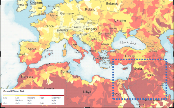
(WRI Water Stress Index Map of Europe and the Middle East, 2019)
These means are first of all extremely useful for better quantifying the available resources. Large-scale monitoring of surface water, for example, is addressed by the SWOT satellite, which will be launched jointly by CNES and NASA in 2022. This programme will make it possible to obtain consistent time series that are essential for current resource management. In addition, the monitoring of extreme events such as droughts or floods will be carried out. The Copernicus programme and its Sentinel satellites also monitor important water cycle variables such as evapotranspiration and soil conditions. In particular, the moisture in the top few centimetres of soil can be measured by the radar sensors on Sentinel-1. This is an important indication for understanding the infiltration of precipitation into the soil and modelling the state of groundwater resources.
Spatial data is also a great tool for assessing consumption needs. Large-scale land use and segmentation information from space-based observations is an indispensable basis. Sentinel satellites, for example, allow precise identification of crop type, and thus improve water use models for agricultural needs. Domestic needs can also be modelled on a large scale using urbanisation monitoring information.
A global and dynamic monitoring tool.
These modern means of observing our planet will make it possible to set up a large-scale water stress indicator. It will be less dependent on local in-situ data that are sometimes difficult to acquire. The use of this type of data should also make it possible to obtain an indicator with a high update frequency. The revisit period of a given geographical area of the satellites considered (between a few days and a month) should make it possible to set up an indicator capable of better capturing the dynamics and evolution of water stress over time.
The integration of space observation as a tool for combating water stress therefore seems promising. It allows the monitoring of surface water, the modelling of underground resources and a better understanding of consumption. As a result, it has a real role to play in planning access to water.
This tool was actually used in 2004 during an operation in Darfur (Chad). Space observation made it possible to propose a map of the possible groundwater available in a region hosting numerous humanitarian camps. The camps were then able to use this information to set up their camps and dig wells. In this way, they are making it easier to access water.
It should be noted that at that time this international initiative used data provided by Japanese (JERS-1), American (Landsat) and European (ESA’s ERS-1 and ERS-2) satellites.
Today, the Sentinel fleet (in particular the Sentinel-1 radar tools) and the mass of free and open data that the Copernicus services produce thanks to them are favoured and should make it possible to move this type of use from research to operational services.
Authors : Fabien Castel, Rémi Nassiri