The Flockeo platform proposes an innovative approach : Travelers become their own guides by choosing sustainable destinations!
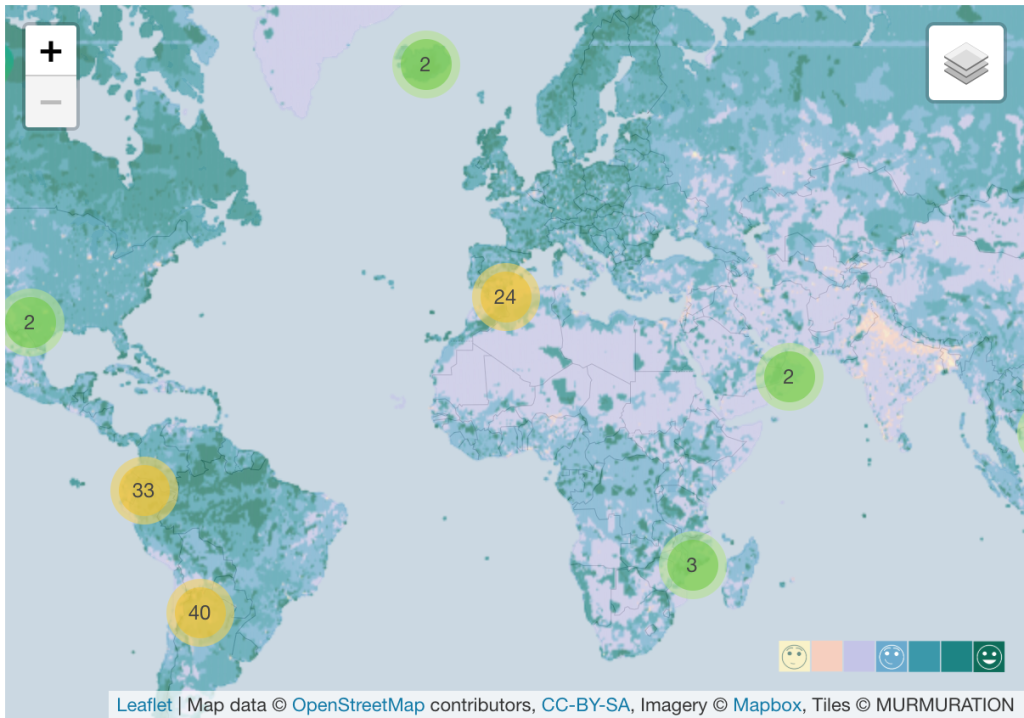
Our approach is inspired by the European Commission’s ETIS indicator system , developed to assess the sustainability of tourism destinations. By combining satellite and statistical data, the Flockeo indicator measures the pressure of human activities on the environment. Thanks to an interactive map, users can zoom in on the destinations that interest them and know the index of the region concerned. Through a colors rating, they will be able to easily assess the impact of human activities through four criteria: the ecosystem potential, the risks related to water and the urbanization processes.
This inclusive approach is possible thanks to satellite data. Combined with various data from local authorities or even the general public (eg tourism statistics), it is possible to envisage large-scale sustainable tourism . The satellite data are factual and invaluable because they allow to go back in time, to identify the problems but also the solutions and to foresee future evolutions.
Through this platform, our desire is to create a global ecosystem that promotes sustainable practices through the linking of all stakeholders in tourism. Whether they are hotels, travel agencies, restaurants, guides, tourist offices, national parks, associations, they need to make themselves known and make their actions visible. These are choices that require significant investment. To highlight them in our platform is our primary mission so that they can devote their time and their budgets to concrete actions.
Sustainable tourism is associated with environmental issues, but not only. It brings together all aspects of sustainable development and also concerns corporate social responsibility. For a travel professional, it’s about maintaining a “spirit of the place” that values the geographical characteristics of a destination through its biodiversity, its cultural wealth, its heritage and the well-being of the inhabitants of the place.
Copyright image ImaginEarth
MURMURATION SAS is currently working on the FLOCKEO web platform to offer travelers and travel professionals a map of the world to know the environmental impact on destinations.

The FLOCKEO barometer uses 3 essential indicators that combined satellite data with other data to evaluate the ecological footprint on tourist destinations.
The International Union for the Conservation of Nature (IUCN) is one of the world’s leading organizations dedicated to the protection and preservation of nature. The FLOCKEO barometer takes into account data from protection programs at international, national and / or regional level and also the quality controls to ensure their effectiveness.
Satellite data combined with other data sources can be used to estimate the risks related to water. The FLOCKEO barometer takes into account the quantity, the quality, as well as the existence and the relevance of the infrastructures for a better management of water around the world.
The indicator makes it possible to specify low density areas as well as very dense urban areas by combining several data, including satellite data. The FLOCKEO barometer thus guides travelers to more or less dense urban areas and creates their own “green” journey.
D-3 before the official release of the FLOCKEO website
Climate change affects all regions of the world. Polar ice caps are melting and ocean levels are rising. In some regions, extreme weather events and precipitation are becoming more frequent, while others are facing increasingly extreme heat waves and droughts. Floods are the most expensive natural disasters in the world. The cost of flood damage amounts to billions of euros. Also, the human losses are dramatic.
#1 Sierra Leone : more than 500 dead and 810 missing as a result of a landslide caused in 2017 by intense rains.
#2 United States : 42 victims after hurricane Harvey and 30,000 displaced people.
#3 Niger: 44 victims during the monsoons of 2017 and more than 70,000 victims.
#4 China: The 2017 floods were responsible for 228 deaths and 3.5 million displaced people across the country.
#5 Sri Lanka : 300 deaths from a dengue epidemic, whose floods have spurred proliferation.
#6 Central Africa : Persistent drought, consecutive cyclones and floods have completely devastated crops in this region, which is highly dependent on rainfed agriculture and smallholder farmers. Nine countries in the region will be most affected by the climate crisis in the coming years: Malawi, Mozambique, the Democratic Republic of Congo (DRC), Tanzania, Zambia and Zimbabwe.
#7 Floods in Venice : For the past few days, St. Mark’s Basilica has been weakened by a historic high tide! Water has flooded the cafe terraces and has even flooded the hotels. the tourists had to return to their hotels, sometimes even passing through the windows.
Satellite images are a powerful tool for Earth observation and monitoring sensitive areas. As part of the Copernicus program and mandated by the European Commission, ESA (European Space Agency) has implemented the Sentinel satellites, the guards of the planet. Thanks to this program, we could detect hydrocarbon pollution at large of the Brazilian coasts and provide evidence for local authorities to help uncover the origin of this major disaster.
At MURMURATION, we confirm the catastrophic situation that these Brazilian coasts are currently experiencing. As shown in the following Sentinel images, we are able to detect oil pollution off the Brazilian coasts in the east, in the state of Bahia.
Oil slicks are observed spanning over 20km, which corresponds to 800 Tennis courts!
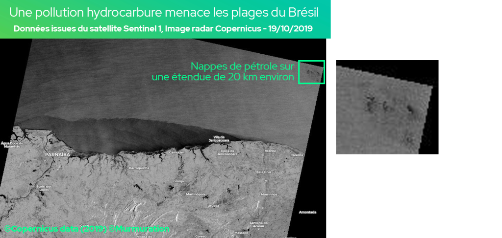
The Sentinel 1 radar images of the Copernicus program provide all-weather imagery (passing through cloud cover) thus enabling the handling of emergency situations (natural or industrial disasters) and environmental monitoring (sea ice, glaciers, water extents, landslide, and so on).
An extent of about 10 km of oil slicks was observed off Açu de Torre … which corresponds to nearly 400 tennis courts!
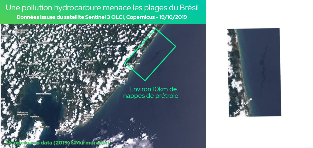
Sentinel 3 OLCI satellite images (Ocean and Land Color Instrument) allow measuring the state of the oceans and coastal zones (pollution, current …) thanks to color levels (spectral bands).
The Brazilian oil spill is an unprecedented ecological disaster with a short, medium and long-term impacts on the natural ecosystems and the economy of the country. Marine ecosystems are becoming stagnant while the country’s economy can be affected. Brazilian beaches, reputed for their beauty and attracting tourists from all over the world, may be deserted by travelers. The tourism sector is already heavily impacted by the situation ! But the worst is yet to come : Cleaning is almost impossible under current conditions.
O óleo no Nordeste e a destruição da Amazônia mostram as consequências do desmonte ambiental promovido pelo governo, prejudicando a imagem do país. Os impactos são gravíssimos para os oceanos, a Amazônia e a vida das pessoas. https://t.co/1PR9Rh6a1B #InimigoDoMeioAmbiente pic.twitter.com/sfZd2MxEla
— Greenpeace Brasil (@GreenpeaceBR) October 23, 2019
The term “Murmuration” describes the phenomenon by which starlings gather spontaneously in the air to face a predator. Faced with the exponential growth of mass tourism and its negative effects on the environment, MURMURATION SAS’s approach is similar: to create an ecosystem of engaged actors from the tourist sector to quantify the environmental pressure on popular destinations and to limit its impacts in the context of climate change. It aims to create better conditions for the development of a sustainable tourism!
October 2018, the Philippines reopen Boracay, a paradise island previously soiled by mass tourism. December 2018, the famous Thai island Koh Phi Phi lacks water because of the number of tourists. April 2019, Dubrovnik tries to manage the overtourism. June 2019, deaths on the slopes of Everest increase because of overtourism …
Many stories like those ones demonstrate the effects of mass tourism. Over-frequentation? Bad tourism management? In any case, prevention is better than cure. While tourism accounts for 8% of global greenhouse gas emissions (according to the Allenvi 2019 study), it is also a socio-economic catalyst and a factor in preserving the environment through the development of new trends such as sustainable tourism.
All the stakeholders have to help safeguard the places that make us dream during our travels. Tourists, tourism professionals, local authorities, associations and NGOs, governments, … All must collaborate so that the tourism activity can be a real promise of economic and social development, while preserving biodiversity and local life in a sustainable way.
Study case : Bali, a tourism booming. How to deal with environmental pressure?
This inclusive approach is possible thanks to satellite data. Combined with various data from local authorities or even the tourists (eg tourism statistics), this innovative solution aims to set up environmental pressure indicators on a global scale. Indeed, the observation of a dedicated area thanks to high-resolution satellite data allows to give reliable and transparent indicators. The satellite data are factual and invaluable because they allow to go back in time, to identify the problems but also the solutions and to foresee future evolutions.
Copyright image : rawpixel de Pixabay
Satellites offer us an incomparable view of our planet thanks to spatial data
(more…)What is essential in your growth strategy and sustainable development? Spatial data
(more…)